

Looming rain threatens to add to Red River Basin woes
Advertisement
Read this article for free:
or
Already have an account? Log in here »
To continue reading, please subscribe:
Monthly Digital Subscription
$0 for the first 4 weeks*
- Enjoy unlimited reading on winnipegfreepress.com
- Read the E-Edition, our digital replica newspaper
- Access News Break, our award-winning app
- Play interactive puzzles
*No charge for 4 weeks then price increases to the regular rate of $19.00 plus GST every four weeks. Offer available to new and qualified returning subscribers only. Cancel any time.
Monthly Digital Subscription
$4.75/week*
- Enjoy unlimited reading on winnipegfreepress.com
- Read the E-Edition, our digital replica newspaper
- Access News Break, our award-winning app
- Play interactive puzzles
*Billed as $19 plus GST every four weeks. Cancel any time.
To continue reading, please subscribe:
Add Free Press access to your Brandon Sun subscription for only an additional
$1 for the first 4 weeks*
*Your next subscription payment will increase by $1.00 and you will be charged $16.99 plus GST for four weeks. After four weeks, your payment will increase to $23.99 plus GST every four weeks.
Read unlimited articles for free today:
or
Already have an account? Log in here »
Hey there, time traveller!
This article was published 10/05/2022 (1309 days ago), so information in it may no longer be current.
A slow-moving Colorado low could dump about 60 millimetres of rain in Manitoba starting Wednesday, renewing spring flood fears as some communities shore up defences.
The last of two rainstorms this week could cause river levels to rise again or prolong severe flooding in the Interlake and Red River Valley.
“Another period of precipitation over the basin will just make things worse,” said Natalie Hasell, a warning preparedness meteorologist with Environment Canada. “This isn’t it. The next storm is not the end. We could be in this for an extended period of time.”
The low-pressure system is forecast to move across the Canada-U.S. border Wednesday, with the Winnipeg area getting the bulk of its rain Thursday.
Severe thunderstorms are possible, and there is a chance the low could stall over the province.
The Parkland, Interlake and eastern areas will continue to receive rain Friday, with showers lingering in some places Saturday.
Hasell said there is still some uncertainty, but 20 to 60 mm is possible in southern and central areas, with a chance of higher amounts locally in thunderstorms.
Wind gusts of up to 60 km/h could cause further erosion in flood zones.
The province has issued an overland flood watch for all of southern and central Manitoba.
Hasell said the rain will be followed by dry, cooler weather, but another low-pressure system is possible next week.
A rainstorm that hit Monday and lingered into Tuesday dumped widespread amounts of 10 to 30 mm.
The highest totals were in western Manitoba, where 52.6 mm fell in Forrest, about 10 kilometres north of Brandon. The Forks in downtown Winnipeg received 22 mm.
The looming storm is not good news for people dealing with floodwater in Fisher River and Peguis First Nations and the Red River Valley. The province said Tuesday the Red had crested at St. Jean Baptiste and was nearing its crest at Morris.
Fisher River Cree Nation, about 200 km north of Winnipeg, is raising flood barriers to prepare for the previous peak level plus one foot.
“I hope (the rain) is going to miss us, but we haven’t been fortunate. Every time they predict rain for the Interlake, it hits us good,” said Chief David Crate. “The water has nowhere to go. We’re getting a lot of overland flooding in the community.”
Crate said about 40 homes impacted by the flood along the Fisher River are protected by Tiger Dams — a barrier of water-filled tubes. The province sent a shipment of extra tubes Monday.
“We’ve been at this a long time. We have a flood team going 24-7 right now,” said Crate.
A similar effort is underway to the south in Peguis, where the number of evacuees is nearing 2,000.
More than 100 Fisher River residents have left their homes, mostly because they have health-care needs, are older or have lost access due to flooded roads.
Provincial Road 224, the community’s main route, and low-lying roads are submerged, making it tougher to deliver fuel, food and other supplies.
Crate is eager to sit down with Ottawa and Manitoba to discuss permanent flood protection, such as a diversion, to protect homes near the Fisher River.
As of Tuesday, there were 425 flood evacuees from municipalities in southern Manitoba, a spokesman for the province said.
In the Red River Valley, communities and most rural properties are safe thanks to ring dikes or other upgrades since 1997’s Flood of the Century.
Ring dike closures, washed out roads and flooded fields are a big inconvenience, especially for commuters and farmers whose seeding season or other work has been disrupted.
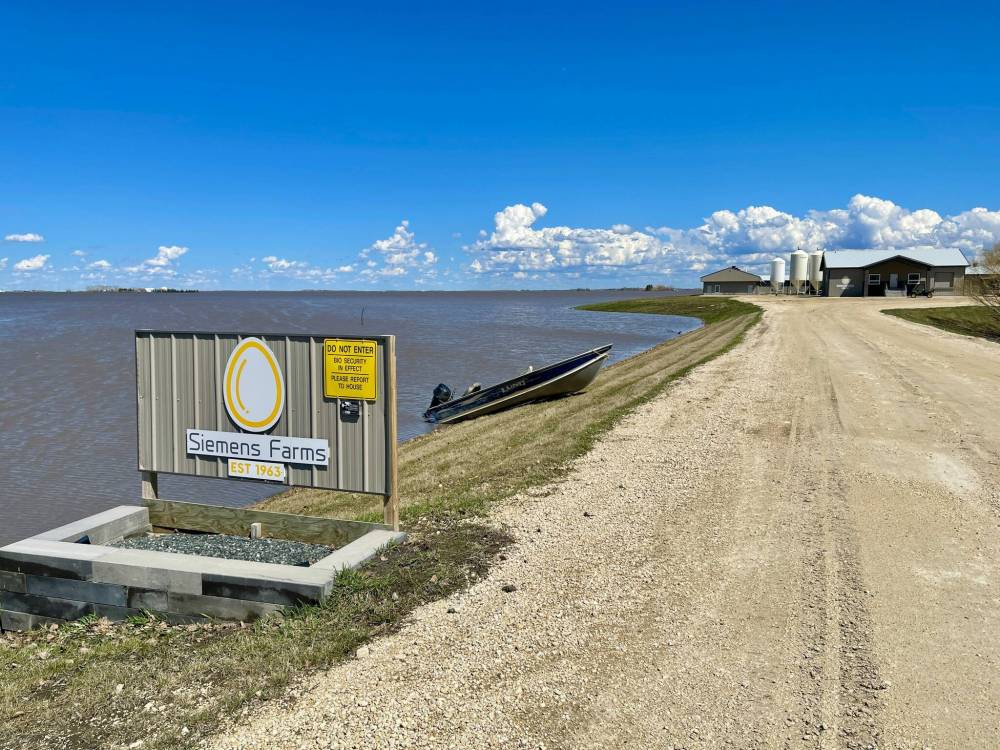
Life is plodding along for egg farmer Harley Siemens, whose land between Rosenort and Morris is surrounded by water.
The only drivable road to the property is about a foot beneath the surface, with wooden stakes marking its edges. Waves lap against large trucks as they crawl along the submerged road at 10 km/h.
“You can’t see the road, so you want to make sure it’s not washed out or soft because it can suck you into the ditch,” said Siemens, who runs Siemens Farms with his father, Kurt. “If the water goes up too much more, we do have a fishing boat that we’ll use if we need to.”
His wife, Brooklyn, and their three children are staying with family in Rosenort, after receiving a voluntary evacuation notice.
Siemens said he had to do a lot of planning last week to ensure feed for hens continues to be delivered and eggs are shipped out. The farm will be able to manage for weeks if trucks can no longer get in or out, he said.
It’s a similar story for Joan and Russ Hackie, whose house in the Rural Municipality of Ritchot is cut off for the first time since 2011, after Marchand Road and Red River Drive flooded.
That year, their land was in the “marination stage” for five weeks, said Joan.
For at least a week, the Hackies have been using a boat to get to and from vehicles parked on a road that isn’t under water.
“We’re on an island,” said Joan. “In weather like (Monday’s) rain, you don’t plan on going anywhere unless you absolutely have to.”
Her road is under more than a metre of water in some spots, with a very strong current. “Under (the surface), it’s become kind of like rapids and just churns. It eats the (gravel) road and erodes it away.”
City of Winnipeg staff continue to meet with provincial flood forecasters daily and monitor river levels.
The city isn’t advising any at-risk properties to build a dike, said spokeswoman Lisa Marquardson.
chris.kitching@freepress.mb.ca
Twitter: @chriskitching
As a general assignment reporter, Chris covers a little bit of everything for the Free Press.
Our newsroom depends on a growing audience of readers to power our journalism. If you are not a paid reader, please consider becoming a subscriber.
Our newsroom depends on its audience of readers to power our journalism. Thank you for your support.
Related Articles
Staying put, staying strong in Peguis despite flooding
Advertisement Advertise With Us
Advertisement Advertise With Us