

Weary flood fighters cast wary eye at rainy forecast

Advertisement
Read this article for free:
or
Already have an account? Log in here »
To continue reading, please subscribe:
Digital Subscription
One year of digital access for only $75*
- Enjoy unlimited reading on winnipegfreepress.com
- Read the E-Edition, our digital replica newspaper
- Access News Break, our award-winning app
- Play interactive puzzles
*Billed as $5.77 plus GST every four weeks. After 52 weeks, price increases to the regular rate of $19.95 plus GST every four weeks. Offer available to new and qualified returning subscribers only. Cancel any time.
Monthly Digital Subscription
$4.99/week*
- Enjoy unlimited reading on winnipegfreepress.com
- Read the E-Edition, our digital replica newspaper
- Access News Break, our award-winning app
- Play interactive puzzles
*Billed as $19.95 plus GST every four weeks. Cancel any time.
To continue reading, please subscribe:
Add Free Press access to your Brandon Sun subscription for only an additional
$1 for the first 4 weeks*
- Enjoy unlimited reading on winnipegfreepress.com
- Read the E-Edition, our digital replica newspaper
- Access News Break, our award-winning app
- Play interactive puzzles
*Your next Brandon Sun subscription payment will increase by $1.00 and you will be charged $17.95 plus GST for four weeks. After four weeks, your payment will increase to $24.95 plus GST every four weeks.
Read unlimited articles for free today:
or
Already have an account? Log in here »
Hey there, time traveller!
This article was published 08/05/2022 (1547 days ago), so information in it may no longer be current.
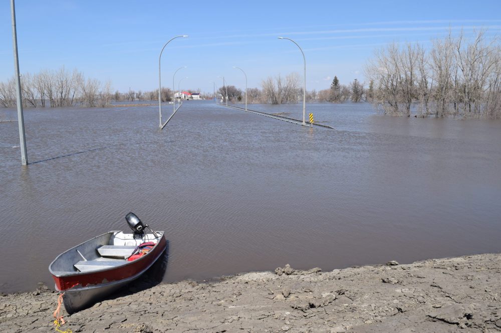
Flood-hit communities in Manitoba are bracing for two Colorado lows to dump heavy rain this week, as the storms threaten to prolong the exhausting fight against high water levels.
Environment Canada issued a special weather statement for much of southern Manitoba and some central areas.
The forecaster said widespread amounts of 20 to 30 mm are expected Monday, as the first low-pressure system moves in from the Dakotas.

The storm could bring 15 to 30 millimetres of rain to the Red River Valley and 10 to 25 mm to the Interlake, said Scott Kehler, president and chief scientist of Weatherlogics.
There is a chance of isolated higher amounts in thunderstorms.
“It certainly will worsen the flood scenario,” Kehler said of the two low-pressure systems, after a series of Colorado lows dumped large amounts of snow and rain earlier this spring. “There are a lot of areas that don’t need the rain.”
The second storm is forecast to hit Thursday, although the exact track and rainfall amounts are still unclear.
Between 15 to 30 mm is possible in the Red River Valley and 25 mm or more in the Interlake and western Manitoba.
“It looks like a larger storm overall, but the impacts will be tricky to predict until we get closer,” said Kehler.
He said the number of Colorado lows to hit Manitoba this spring is unusual.
“I’m almost losing count at this point,” he added. “With these strong Colorado lows, that kind of activity becomes a lot more common the further you get into summer, when they’re fuelled by warm and humid air.”
Manitoba’s flood forecasters are expecting a total of 40 to 60 mm of rain this week, with higher amounts possible in some localized areas. The province said water level forecasts will be updated to determine the impacts on flood zones.
The predictions bring more gloom to residents of the Red River Valley and Interlake, who’ve been dealing with flooding for more than a week.
A flood in Peguis First Nation has forced about 1,600 residents to leave their homes and affected more than 700 residences.
An ice jam caused the Fisher River to inundate the community about 170 kilometres northwest of Winnipeg, after an earlier prediction said the probability of a spring flood was low.
Last week, the province said the river was expected to recede within its banks on or around Monday.
South of Winnipeg, the Red was expected to crest in Emerson on Sunday, and elsewhere by the end of this week.
According to the pre-rainfall forecast, peak flows are expected to continue for five to seven days before water levels gradually recede.
A peak similar to 2009 is expected in Emerson, while levels to the north are likely to be between the peaks of 2009 and 2011.
Flood expert Jay Doering, a professor of civil engineering at the University of Manitoba, expects this week’s rainfall to sustain the river’s peak.
“It’s kind of dragging it on,” he said.
He said it’s premature to predict the precise impact of back-to-back Colorado lows.
“We need to sit tight and see how much rain we get and the extent of the watershed it covers,” said Doering. “It’s going to push water levels in the valley, but there is still a modest amount of freeboard available for the elevation of community ring dikes.”
Dave Carlson, reeve of the Municipality of Emerson-Franklin, is hoping water levels don’t rise again.
“We’ll just have to monitor it and do the best we can,” he said. “Hopefully, there won’t be as much rain as they’re saying. It potentially could prolong the peak.”
Carlson said he is concerned about strong winds in Monday’s forecast, after powerful gusts on Saturday led to more erosion and pushed around debris in floodwaters.
Rural Municipality of Morris Reeve Ralph Groening said an extended peak will heap more work and pressure on flood-affected municipalities, and more stress on residents.
“We’re watching, with some concern, the proposed weather system coming,” he said. “We’re close to the end, but the rain is an unwelcome addition to what’s been a six-week flood fight. Our staff are weary, and the residents, as well.”
Groening said about 70 people in the RM of Morris have left their homes due to flooded roads.
Evacuation notices have been given to at least 190 homes in the RM of Ritchot.
Communities and most individual properties in the Red’s flood zone are protected by ring dikes or other upgrades made since the Flood of the Century in 1997.
Many gravel roads and some bridges are submerged, and farmers’ fields have been turned into lakes.
Once the water recedes, said Doering, rural municipalities will have to examine their infrastructure to determine how to lessen the impact of future floods.
“We’re clearly seeing that culverts are not large enough, and bridges and roads are not high enough,” he said.
The RM of Morris is building a database of damaged roads that will undergo repairs in the weeks or months to come.
“An extended flood crest will certainly add to that,” said Groening, noting the municipality is waiting for the province to announce a disaster financial assistance program.
At least 26 municipalities have declared local states of emergency. The total doesn’t include First Nations, including Peguis, which have also declared emergencies.
chris.kitching@freepress.mb.ca
Twitter: @chriskitching
Chris Kitching is a general assignment reporter at the Free Press. He began his newspaper career in 2001, with stops in Winnipeg, Toronto and London, England, along the way. After returning to Winnipeg, he joined the Free Press in 2021, and now covers a little bit of everything for the newspaper. Read more about Chris.
Every piece of reporting Chris produces is reviewed by an editing team before it is posted online or published in print — part of the Free Press‘s tradition, since 1872, of producing reliable independent journalism. Read more about Free Press’s history and mandate, and learn how our newsroom operates.
Our newsroom depends on a growing audience of readers to power our journalism. If you are not a paid reader, please consider becoming a subscriber.
Our newsroom depends on its audience of readers to power our journalism. Thank you for your support.
Related Articles
Weary, waterlogged Manitobans cast wary eye on the sky
Advertisement Advertise With Us
Advertisement Advertise With Us
History
Updated on Sunday, May 8, 2022 6:37 PM CDT: Environment Canada statement
Updated on Friday, May 13, 2022 10:17 AM CDT: Changes to Jay from Joe Doering