Major snowfall set to blanket southern Manitoba
Advertisement
Read this article for free:
or
Already have an account? Log in here »
To continue reading, please subscribe:
Digital Subscription
One year of digital access for only $75*
- Enjoy unlimited reading on winnipegfreepress.com
- Read the E-Edition, our digital replica newspaper
- Access News Break, our award-winning app
- Play interactive puzzles
*Billed as $5.77 plus GST every four weeks. After 52 weeks, price increases to the regular rate of $19.95 plus GST every four weeks. Offer available to new and qualified returning subscribers only. Cancel any time.
Monthly Digital Subscription
$4.99/week*
- Enjoy unlimited reading on winnipegfreepress.com
- Read the E-Edition, our digital replica newspaper
- Access News Break, our award-winning app
- Play interactive puzzles
*Billed as $19.95 plus GST every four weeks. Cancel any time.
To continue reading, please subscribe:
Add Free Press access to your Brandon Sun subscription for only an additional
$1 for the first 4 weeks*
- Enjoy unlimited reading on winnipegfreepress.com
- Read the E-Edition, our digital replica newspaper
- Access News Break, our award-winning app
- Play interactive puzzles
*Your next Brandon Sun subscription payment will increase by $1.00 and you will be charged $17.95 plus GST for four weeks. After four weeks, your payment will increase to $24.95 plus GST every four weeks.
Read unlimited articles for free today:
or
Already have an account? Log in here »
Hey there, time traveller!
This article was published 10/04/2022 (1551 days ago), so information in it may no longer be current.
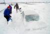
Southern Manitoba can expect significant snowfall beginning late Tuesday night, but just how much shovelling will be required and what effect the storm has on spring flooding remains to be seen.
Provincial flood forecasters warned on Saturday of significant precipitation expected in central and southern Manitoba and the U.S. portions of Manitoba basins between Tuesday and Friday. The province’s flood bulletin noted an expectation of 30 to 80 centimetres of snow.
On Sunday, forecast models were aligning to form a clearer picture of the significant weather that is on the way.

“This will probably be the biggest spring storm in a quarter-century,” Brad Vrolijk, lead forecaster with Environment and Climate Change Canada, said.
In 1997, a storm on April 5 dumped 48 cm of snow on Winnipeg. The ensuing melt prompted one the province’s largest recorded spring flood events — what became known as the Flood of the Century.
Storm conditions are forecast to develop late Tuesday night into early Wednesday morning as a Colorado low brings snow and strong winds to the region.
Vrolijk said 10 to 40 cm of snow is expected across southern Manitoba. The lowest snowfall amounts are expected near the Saskatchewan border, while the highest snowfall amounts are expected to drop on southeastern Manitoba.
Some pockets of the province might receive more, Vrolijk added, with 50 to 70 cm of precipitation possible.
Winnipeggers should expect 25 to 40 cm, he said.
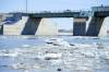
Flood forecasters advised on Saturday that the Red River has crested at St. Adolphe. Flood warnings remain in effect between St. Jean Baptiste and Morris, at St. Adolphe and around Selkirk because of ice jams.
Earlier this spring, flood forecasters downgraded the province’s flood risk because of average precipitation and a slow spring melt. Though significant snowfall appears assured this week, temperatures in the days after appear likely to support a continued slow melt.
While Vrolijk left flood forecast speculation to the province’s hydrologic forecast centre, he noted a quick rise in temperatures is not expected.
In a weather advisory issued Sunday, Environment Canada said freezing temperatures are projected until April 19 and that runoff is not anticipated before April 20.
Strong winds in the coming days are expected to create blizzard conditions. Blowing snow is likely on Wednesday night through Thursday, before conditions improve on Friday. Poor visibility is expected to create treacherous road conditions.
“Travel may become impossible. Anybody who needs to travel should be checking travel conditions,” Vrolijk said.
fpcity@freepress.mb.ca