

Red River crests from Emerson to St. Adolphe
Advertisement
Read this article for free:
or
Already have an account? Log in here »
To continue reading, please subscribe:
Digital Subscription
One year of digital access for only $75*
- Enjoy unlimited reading on winnipegfreepress.com
- Read the E-Edition, our digital replica newspaper
- Access News Break, our award-winning app
- Play interactive puzzles
*Billed as $5.77 plus GST every four weeks. After 52 weeks, price increases to the regular rate of $19.95 plus GST every four weeks. Offer available to new and qualified returning subscribers only. Cancel any time.
Monthly Digital Subscription
$4.99/week*
- Enjoy unlimited reading on winnipegfreepress.com
- Read the E-Edition, our digital replica newspaper
- Access News Break, our award-winning app
- Play interactive puzzles
*Billed as $19.95 plus GST every four weeks. Cancel any time.
To continue reading, please subscribe:
Add Free Press access to your Brandon Sun subscription for only an additional
$1 for the first 4 weeks*
- Enjoy unlimited reading on winnipegfreepress.com
- Read the E-Edition, our digital replica newspaper
- Access News Break, our award-winning app
- Play interactive puzzles
*Your next Brandon Sun subscription payment will increase by $1.00 and you will be charged $17.95 plus GST for four weeks. After four weeks, your payment will increase to $24.95 plus GST every four weeks.
Read unlimited articles for free today:
or
Already have an account? Log in here »
Hey there, time traveller!
This article was published 09/04/2022 (1551 days ago), so information in it may no longer be current.
The Red River has peaked between Emerson and St. Adolphe, the province’s Hydrologic Forecast Centre said Saturday, ahead of an expected significant snowstorm.
The forecasters are monitoring an expected precipitation system that will likely affect central and southern Manitoba, as well as the U.S. portions of the Red’s basin, next week.
The centre expects the system will bring between 30 and 80 cm of snow, or a possible mix of snow and rain. Forecasters expect the temperatures to drop below freezing this Wednesday and stay there until April 19 across most of southern Manitoba.

Forecasters don’t expect any runoff until April 20.
The Manitoba government activated the Red River Floodway on Friday morning to protect low-lying riverside properties in Winnipeg from flooding.
Flood warnings remain in effect for the Red from St. Jean Baptiste to Morris, at St. Adolphe and in the Selkirk area because of ice jamming, while the province issued a high-water advisory from Emerson to the Red River Floodway inlet except areas already under flood warnings.
Flows and water levels are rising on the Assiniboine River from the Shellmouth Dam to Winnipeg. The forecast centre expects the river to peak between Monday and April 18.
— staff
Related Articles
Major snowfall set to blanket southern Manitoba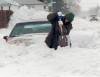
Advertisement Advertise With Us
History
Updated on Saturday, April 9, 2022 4:40 PM CDT: Fixes hed, corrects spelling of St. Jean Baptiste