

Winter storm raises spring flood fears

Advertisement
Read this article for free:
or
Already have an account? Log in here »
To continue reading, please subscribe:
Digital Subscription
One year of digital access for only $75*
- Enjoy unlimited reading on winnipegfreepress.com
- Read the E-Edition, our digital replica newspaper
- Access News Break, our award-winning app
- Play interactive puzzles
*Billed as $5.77 plus GST every four weeks. After 52 weeks, price increases to the regular rate of $19.95 plus GST every four weeks. Offer available to new and qualified returning subscribers only. Cancel any time.
Monthly Digital Subscription
$4.99/week*
- Enjoy unlimited reading on winnipegfreepress.com
- Read the E-Edition, our digital replica newspaper
- Access News Break, our award-winning app
- Play interactive puzzles
*Billed as $19.95 plus GST every four weeks. Cancel any time.
To continue reading, please subscribe:
Add Free Press access to your Brandon Sun subscription for only an additional
$1 for the first 4 weeks*
- Enjoy unlimited reading on winnipegfreepress.com
- Read the E-Edition, our digital replica newspaper
- Access News Break, our award-winning app
- Play interactive puzzles
*Your next Brandon Sun subscription payment will increase by $1.00 and you will be charged $17.95 plus GST for four weeks. After four weeks, your payment will increase to $24.95 plus GST every four weeks.
Read unlimited articles for free today:
or
Already have an account? Log in here »
Hey there, time traveller!
This article was published 04/04/2023 (1214 days ago), so information in it may no longer be current.
A Colorado low laden with snow and bearing down on southeast Manitoba is dampening hopes for imminent warm weather and raising future flood fears.
Amanda Lee, a Grand Forks, N.D.-based hydrologist with U.S. agency National Weather Service, said even before this week’s expected snowfall, the chance of a flood on the Red River on the American side was “moderate to major.”
“Now, with this precipitation, probably an additional inch of liquid water equivalent and maybe higher, it will bump up that flood risk even more,” she said Tuesday afternoon.
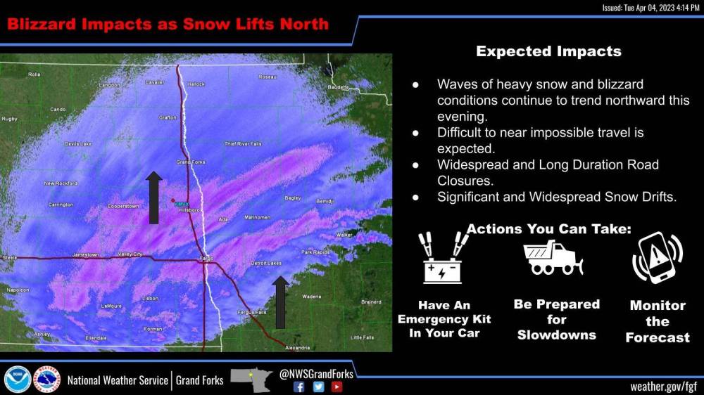
U.S. National Weather Service radar image of the Colorado low affecting North Dakota Tuesday afternoon.
As of that time, Fargo, N.D., was being hit by snow and Grand Forks was next on the list. Lee said service forecasters will be examining the flood models in the wake of the storm.
“When this snow melts, it will move north,” she said, adding, compared to southern areas of North Dakota, there is much less snow on the land closer to the international border to flow into the Red River.
A statement by the provincial government Monday said Manitoba’s hydrologic forecast centre is monitoring the weather system and will issue updated river flow and level forecasts once it passes.
Last month, after North Dakota received a major snowfall, the province changed what had been until then a moderate risk of flooding along the Red River to a major risk. Most of the rest of the province only has a low to moderate risk of flooding.
Environment Canada warning preparedness meteorologist Natalie Hasell said the agency is anticipating the Colorado low will bring up to 25 centimetres of snow to southern parts of the province — ranging from an estimated 15 cm in Winnipeg to 25 cm around Sprague.
“The low is still in Colorado,” Hasell said mid-afternoon Tuesday. “It will be here sometime (Tuesday night).
“The low itself will stay south of the border — we will have the northern extension. (The U.S. side is) looking at 30 to 40 cm of snow… But we will also have strong winds… so it will be difficult out there. We want people to stay off the road.”
And those long-range forecasts showing highs of above 10 C on the weekend and Monday? You can dash those hopes.
“A shot of cold will be here as this moves off,” Hasell said. “It will be -15 C on Friday morning. That’s quite cold at this time of year. Temperatures reaching above 10 (C) this weekend and on Monday is unlikely now.”
Jack Froese has farmed near Winkler for about a half-century. He is a fourth-generation farmer, whose land began production in 1874.
On Tuesday, Froese said he was beginning to see dark soil at the edges of his fields. He expected the looming blizzard will serve as a big white eraser.
“When the snow is dark, it melts faster,” he said. “If we get 10 or 12 inches of snow now, it will put everything back about 10 days to two weeks. Last year, we didn’t start seeding until May 17, but usually we’re in the fields the last week of April.”
While he is far from the Red River, so his land won’t flood from there, Froese said farmers in the area could have a problem, because the closer the snow comes to warmer spring weather, the quicker the melt.
“Truckers are telling us there is a lot of snow down south,” he said.
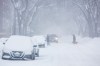
Meanwhile, both the capital city and province has readied their snow-clearing fleets.
In a statement, the City of Winnipeg said crews are monitoring road conditions and are ready to apply salt to improve traction, and deploy equipment, as needed.
Currently, there are no winter parking bans in place.
A spokesman for Manitoba Transportation and Infrastructure said it has 350 pieces of equipment to keep the province’s roads clear.
“No MTI equipment has been converted to summer use,” the spokesman said. “The department is ready to respond to the upcoming snow event on all routes in the province.”
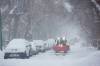
Canadian Automobile Association spokeswoman Elisha Dacey warned Manitobans if they venture out on the province’s highways mid-storm, they could be on their own.
“CAA trucks cannot rescue people stranded on closed roads,” Dacey said. “If at anytime you feel you are in immediate danger, call local police or RCMP for assistance.
“Safety is always our first priority. We ask our members and all Manitobans to reconsider travel plans over the next few days until the storm passes and roads are clear.”
The Winnipeg Regional Health Authority issued a warning Tuesday the storm could impact its community health services, especially home care.
The WRHA said it will contact clients by phone if visits will be postponed or cancelled, while other visits could be “delayed, rescheduled or cancelled.”
“We anticipate that service will resume as per usual once the storm has cleared and we apologize in advance for any disruption this may cause our clients.”
kevin.rollason@freepress.mb.ca
Kevin Rollason is a general assignment reporter at the Free Press. He graduated from Western University with a Masters of Journalism in 1985 and worked at the Winnipeg Sun until 1988, when he joined the Free Press. He has served as the Free Press’s city hall and law courts reporter and has won several awards, including a National Newspaper Award. Read more about Kevin.
Every piece of reporting Kevin produces is reviewed by an editing team before it is posted online or published in print — part of the Free Press‘s tradition, since 1872, of producing reliable independent journalism. Read more about Free Press’s history and mandate, and learn how our newsroom operates.
Our newsroom depends on a growing audience of readers to power our journalism. If you are not a paid reader, please consider becoming a subscriber.
Our newsroom depends on its audience of readers to power our journalism. Thank you for your support.
Related Articles
More than 1 million lose power in Quebec, Ontario

Advertisement Advertise With Us
Advertisement Advertise With Us